Public Consultation September 17th – November 6th 2020

WHAT IS THE LOCAL AREA PLAN?
The Draft Local Area Plan (LAP) establishes a framework for the
planned, coordinated and sustainable development for the Kellystown area.
The LAP will take effect for a period of six years following adoption (2020-2026).
The Draft LAP examines the study area in Kellystown in detail, identifying and analysing the various issues affecting the area, establishing and setting principles for its future development.
The preparation of the LAP offers the potential to create a new sustainable neighbourhood including high quality housing, local employment and new
community facilities.
OUR VISION AND DEVELOPMENT STRATEGY
The vision for Kellystown is to promote the development of
a distinctive, sustainable, high quality new residential quarter,
connected to the neighbouring suburbs of Clonsilla and
Carpenterstown. Kellystown will provide a sustainable residential
community, comprising a choice of high quality new homes, with
a mix of dwelling types, size and tenure based around a new civic
square that incorporates local services with new schools, public
open space and access to high capacity public transport links.
Background
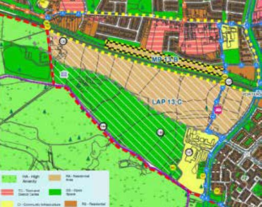
Kellystown Local Area Plan (LAP) comprises lands located directly
south of the Royal Canal and the Dublin-Maynooth Railway
Line and located between Diswellstown Road to the east and
Clonsilla Road (R121) to the west. Under the Fingal Development Plan 2017-2023 the applicable land use zonings are:
- Residential Area (RA) to ‘provide for new residential communities subject to the provision of the necessary social and physical infrastructure’
2. Open Space to ‘preserve and provide for open space and recreational amenities’.

KEY PRINCIPLES:
Creating Communities:
Establish community focal points for people to socialise, gather and enjoy recreational facilities e.g. civic square, schools, local level services, parks.
Focus on permeability:
Maximise the benefits of investment
in the electrification of the DublinMaynooth railway line; improve public
transport and walking/cycling networks.
Working with the existing landscape and features:
Establish a ‘green axis’ at the centre of the LAP lands that links new residential development.
High quality design:
Encourage best practice sustainable design in new development and high
quality, accessible public spaces.
Meeting peoples housing needs:
Accommodate a variety of dwelling types, tenure and sizes to suit a range
of household sizes, differing needs and varying levels of income.